Live Earth Maps Satellite View
- 3.8
- Rating
- 100.00K
- Installs
- Free
- Price
 Analysis by App-foxy
When I first opened Live Earth Maps Satellite View, I approached it as a simple way to look around unfamiliar places rather than as a full replacement for a dedicated navigation service. That expectation matters. This free Maps & Navigation app from Cybill Tech Mobile Apps brings together map browsing, GPS routes, nearby places, and views of notable locations, so its appeal is in exploring and orienting yourself in one place.
The app has a 3.8 average from around 8.7 thousand ratings, with more than 100 thousand installs. Those figures suggest a useful but mixed experience: plenty of people have tried it, while the score also hints that it will not suit every navigation habit. I found it most interesting when I wanted a broad visual sense of an area, checked what was around a destination, or explored somewhere before deciding where to go.
It is available at no upfront cost and is rated for Everyone. There are optional in-app purchases listed at $8.99 per item, so I would still pay attention to any upgrade prompts during use. The current version is 1.9, and it runs on devices using Android 7.0 or later. The developer is Cybill Tech Mobile Apps, and the app was released on October 8, 2017, which gives it a longer history than many newer map experiments.
You May Also Like

 Blood Strike: 2.5 Anniversary
Blood Strike’s Loadouts Turn Every Drop Into a Tactical Gamble
A close look at Blood Strike’s custom loadouts: how fast access to signature weapons reshapes its battle royale rhythm, rewards preparation, and narrows the gap between fights.

 Pandora - Music & Podcasts
Pandora’s Music Is Easy to Start, but Harder to Recover
Pandora’s strength is its low-effort path from a seed to a station. Its weak spot is how much confidence it asks you to place in connection, setup, and quiet recovery.

 8 Ball Pool
 Is Built on Rivalries, Rematches, and Routine
A close look at the rivalries, rematches, shared routines, and unanswered safety questions that turn a quick pool match into a persistent mobile community.

 Samsung Music
’s Quiet Strength Is Playing What You Already Own
Its reach comes less from spectacle than from dependable access to a personal library. That simplicity is both the app’s strongest retention engine and its ceiling.

 AccuWeather: Weather Radar
AccuWeather Review: A Quick, Clear Forecast for Everyday Decisions
For everyday plans, the best forecast is the one you can understand quickly. AccuWeather makes rain timing, radar, and local conditions easy to act on, with a few trade-offs.

 Hill Climb Racing
Why Hill Climb Racing Still Turns Crashes Into One More Run
A tiny car, a bumpy hill and one more upgrade: Hill Climb Racing keeps resurfacing because its simple chaos makes every near-miss feel personal.
More From Our News Desk



Getting oriented before you depend on it
The first thing I would tell a new user is not to treat the opening map as proof that this is identical to the navigation app already installed on your phone. The wording around live maps, GPS routes, nearby places, and world wonders points to a combination of discovery and route planning. That is useful, but the practical experience depends on what you need at that moment.
If I am walking through a neighborhood I do not know, I want two different kinds of information. I need a visual map to understand the layout, and I need a route that turns that layout into a sequence of actions. An app built around exploration can help with the first part especially well. For the second part, I would test a route before leaving rather than assuming it will provide every traffic, transit, or road detail offered by a specialist service.
The satellite-style perspective is also best understood as a context tool. Looking at a place from above can make a large park, coastline, campus, or group of buildings easier to recognize than a plain street diagram. It can help me confirm that I am looking at the right area before I start moving. It is less helpful when I need to read tiny street labels quickly while standing outside in bright light.
That difference creates one of the app's most useful trade-offs. A visual view can answer “what does this area look like?” faster than a list of search results, while a conventional navigation app may answer “which turn do I take next?” more efficiently. I would use Live Earth Maps Satellite View for the first question and compare its route behavior with my usual tool before making it my only travel aid.
The first setup is simple, but take a moment to check the map
After installation, I recommend starting with a low-pressure location rather than immediately planning an important journey. Search for a familiar place, move around the map, and compare what you see with your own knowledge of the area. This gives you a quick sense of how comfortable the map is to read and whether the visual presentation works for your eyes.
My preferred first setup would be a place I visit regularly, such as a shopping street or a local park. I would locate it, inspect the surrounding roads, and then look for nearby places. This small exercise is more useful than opening an unfamiliar destination first because I can spot an incorrect assumption immediately. If the map feels clear around a known location, I have a better basis for exploring somewhere new.
Keep the first session focused. Rather than tapping every visible option, I would begin by identifying the main map view, the route function, and the nearby-place search. The app's description brings these ideas together, but a first-time user still benefits from learning which action leads to which result. A few minutes of calm testing can prevent confusion later when you are already outside and trying to find a destination.
One practical habit is to plan while connected to a reliable network and leave the app open long enough to inspect the complete route. I would not begin a long trip after only entering a destination and glancing at the first screen. Check the starting point, the general direction, and the final approach. This is particularly important if the destination has several entrances or sits inside a large complex.
I also suggest keeping a backup in mind for essential travel. That is not a criticism unique to this app; it is sensible with any mapping tool. A phone battery problem, a weak connection, or an unclear destination can turn a convenient map into a poor travel companion. For casual exploration, that risk is small. For an appointment, airport transfer, or unfamiliar drive, I would verify the route with another trusted source.
Turning the first map view into a useful result
The first meaningful success should be something concrete: finding a nearby place and understanding how it relates to your current position. In my case, I would open the map around a familiar destination, inspect the surrounding streets, and then use the route option to see how the app connects the starting point with that place. This is a better test than simply admiring the map because it exercises the part that matters when you are actually going somewhere.
For a realistic everyday scenario, imagine arriving in a new town for an afternoon. You know the name of a museum or a landmark, but you do not know whether it is near cafés, parking areas, or a main road. I would first locate the destination, switch attention between the broader map and the surrounding area, and use nearby-place information to shape the visit. The app becomes useful before the journey even begins because it helps me build a mental picture instead of following a line blindly.
Another good test is a short walking route you already know. Choose a nearby destination that takes only a few minutes to reach, then compare the suggested path with the route you normally take. This reveals whether the app's directions feel intuitive without putting you at risk of missing an important turn. If the result is clear and practical, you can gradually try it with less familiar places.
World wonders and notable locations add a different kind of value. I would use that side of the app when planning a trip or simply exploring from home. It turns map browsing into a visual discovery activity rather than making every session about getting from one address to another. For families, students, or curious travelers, that can make the app more enjoyable than a strictly utilitarian route planner.
A useful trick is to use the broad view first and the route view second. Starting with directions can narrow your attention to a line between two points. Looking at the wider area before requesting a route helps me notice alternate approaches, nearby landmarks, and the shape of the destination. This is especially helpful around parks, waterfronts, campuses, and large public spaces where the closest road is not always the best entrance.
Where first-time users may become confused
The word “live” in the short description can create expectations that the app will behave like a complete real-time traffic command center. I would be careful with that assumption. The more reliable way to approach it is as a live map and GPS-oriented exploration tool, then judge the route information on the specific journey you are planning. If you need minute-by-minute traffic decisions, transit departures, or highly specialized driving guidance, a dedicated alternative may be the safer choice.
Satellite imagery can also be misunderstood. An overhead image is excellent for recognizing terrain and large structures, but it does not automatically make every entrance, footpath, or temporary road condition obvious. When I am navigating, I use the visual layer to understand the area and the route information to choose a direction. I do not rely on the picture alone to decide whether a narrow path is open or suitable for my vehicle.
Nearby places can be helpful without being a complete directory. If I am hungry in an unfamiliar area, I would use the results to generate possibilities, then check the selected place's actual entrance and position on the map. A marker may look close while a wall, river, divided road, or restricted access makes the approach less direct. That extra glance at the surrounding layout is one of the small habits that makes the app more useful.
Another point of friction is the balance between free access and optional purchases. Since the app is free but includes in-app purchases priced at $8.99 per item, I would not assume every function is presented in exactly the same way for every user. I recommend exploring the basic map and route workflow first. Only consider an upgrade if a feature you genuinely need is clearly explained and the cost makes sense for your use, rather than purchasing simply because a prompt appears.
The age rating of Everyone makes the app approachable for a broad audience, but that does not remove the need for adult judgment during travel. A child can enjoy looking at world locations with supervision, while an adult should handle decisions involving roads, unfamiliar areas, or personal safety. The rating describes the intended audience, not the accuracy of every route or the suitability of every destination for independent travel.
How it compares with familiar map alternatives
Compared with the standard map app on most phones, Live Earth Maps Satellite View feels more centered on visual exploration. Its combination of map browsing, GPS routes, nearby places, and world locations gives me several reasons to open it when I am curious about an area. A mainstream navigation service will often feel more immediately dependable for turn-by-turn travel, especially when I already know its search behavior and traffic tools.
Compared with a dedicated satellite viewer, this app has a more practical reason to exist because routes and nearby places sit alongside the visual map. The compromise is that users who only want detailed imagery may prefer a specialist tool with a narrower purpose. I see this app as a middle ground: more exploratory than a plain route screen, but more action-oriented than a map that only lets me look around.
That middle ground works best for travelers who plan visually. Before visiting a landmark, I like to understand its surroundings, identify a sensible approach, and see what else is nearby. The app can support that workflow without forcing me to switch immediately between a satellite viewer, a place directory, and a route planner. The benefit is convenience; the cost is that I still need to judge whether its route details are sufficient for a particular trip.
I would recommend it to someone who enjoys discovering places, wants a free way to inspect unfamiliar areas, or prefers seeing a destination in context before setting off. It may also suit a student working through geography topics or a family exploring famous locations together. The visual side gives those users something to do even when they are not actively traveling.
I would skip it as my primary choice if my routine depends on advanced traffic information, highly detailed public transport planning, offline reliability, or professional-grade route control. Those needs call for an app built specifically around them. I would also avoid testing it for the first time during a high-pressure journey. Its strengths are easiest to appreciate when you have time to explore and verify, not when every second counts.
A sensible routine after the first successful route
Once I had confirmed that a short route worked for me, I would use the app in three stages. First, I would explore the destination from a broad view. Second, I would inspect nearby places and likely entrances. Third, I would request the route and compare it with the surrounding map. This sequence reduces the chance of following directions without understanding where they lead.
For a trip to a large attraction, I would save a mental note of a recognizable landmark near the destination rather than focusing only on the final marker. If the last part of the route feels confusing, the wider map can help me reorient. This is one of the app's less obvious strengths: the visual context can be more reassuring than a bare instruction when the destination is surrounded by several roads or open spaces.
I would also use it for pre-trip browsing on days when I am not traveling. Exploring world wonders and unfamiliar neighborhoods can help me decide which places deserve further research. The app is not just a tool I would open after getting lost; it can be part of the planning stage, where curiosity and practical route checking work together.
At the same time, I would keep my expectations measured. A 1.9 version and a 3.8 average indicate that this is a modest, established app rather than something I would automatically place above every major navigation platform. Its value comes from the particular mix of visual maps and discovery tools. If that mix matches how you think about places, the free entry point makes it easy to try. If you only need the fastest, most familiar directions, another app may be more efficient.
After using it, my recommendation is straightforward: install it for exploration and route preparation, then earn your confidence with a familiar short journey. Do not judge it only by the opening map, and do not judge it only by the name “live.” Test the complete workflow from finding a place to understanding the approach. The best results come from using the map as a visual planning companion, not blindly as your only source of travel decisions.
For me, that makes Live Earth Maps Satellite View worthwhile for curious travelers and everyday users who want to see the shape of a place before moving through it. It is less convincing as a universal replacement for mature navigation services, but it offers a friendly path from browsing a location to building a workable plan. If you value that visual step and are comfortable checking important routes carefully, it is a useful free addition to your map collection.
FAQs for Live Earth Maps Satellite View
01What is Live Earth Maps Satellite View?
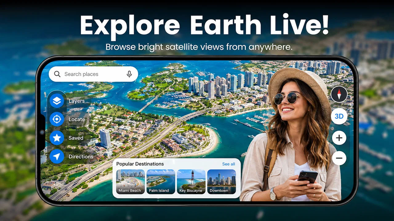
Live Earth Maps Satellite View is a mapping and navigation app that lets you explore satellite imagery, maps, and geographic locations from your mobile device. It may include tools such as live map browsing, address search, route planning, street-level views, compass features, and location sharing. The exact tools can vary by device, region, app version, and available map-data providers.
02Is Live Earth Maps Satellite View really live?
Despite the word “Live” in its name, the satellite imagery is generally not a real-time video feed. Satellite and aerial images are collected periodically and can be weeks, months, or sometimes years old, depending on the location and data source. Traffic conditions, map labels, and other navigation information may update more frequently, but users should not expect to see current events or continuously changing scenes.
03Does the app require an internet connection?
An internet connection is usually needed to load satellite imagery, search places, calculate routes, and update map information. Some features may continue working with limited connectivity if the app supports cached or offline maps, but this should not be assumed for every location. Using satellite imagery and navigation over mobile data can also consume a significant amount of your data allowance.
04Does Live Earth Maps Satellite View track my location or collect personal data?
If you enable location services, the app may use your device’s GPS and network information to show your position, provide directions, or improve nearby searches. Before using it, review the permissions requested and read the app’s privacy policy to understand how location data, searches, device identifiers, and analytics may be handled. You can usually manage location access through Android or iOS settings.
05Is Live Earth Maps Satellite View free to download and use?
The application may be available as a free download, but some features can be supported by advertisements, subscriptions, or in-app purchases. Premium options may include removing ads, unlocking additional map layers, advanced navigation tools, or enhanced imagery. Check the current listing in Google Play or the App Store before downloading, especially for trial periods, recurring subscription charges, and cancellation conditions.
Pros
- Real-time-style satellite imagery helps explore places from a different perspective.
- Map controls are simple enough for casual users to learn quickly.
- Useful for checking terrain
- coastlines
- and major landmarks before a trip.
- Street-level and satellite views can make location browsing more engaging.
- Search tools help users find cities and notable locations without much effort.
Cons
- Image freshness varies
- so some buildings
- roads
- or landscapes may be outdated.
- High-resolution imagery can consume considerable mobile data during extended use.
- Some features may require in-app purchases or display frequent advertising.
- Performance may drop on older phones when loading detailed map imagery.
- Satellite views are less useful in areas with cloud cover or limited coverage.

Live Earth Maps Satellite View
Gallery